直接从 SceneView 对高程进行采样的剖面线。
SceneView 中的所有体积对象都会生成剖面,包括 Ground、SceneLayer、IntegratedMeshLayer 和具有体积 3D 符号的 FeatureLayers(例如 ObjectSymbol3DLayer、PathSymbol3DLayer)。生成剖面时,将排除输入图形本身。当 Camera 更改时,剖面线将更新以反映视图中当前可见的内容。
此剖面线类型在 MapView 中不受支持。
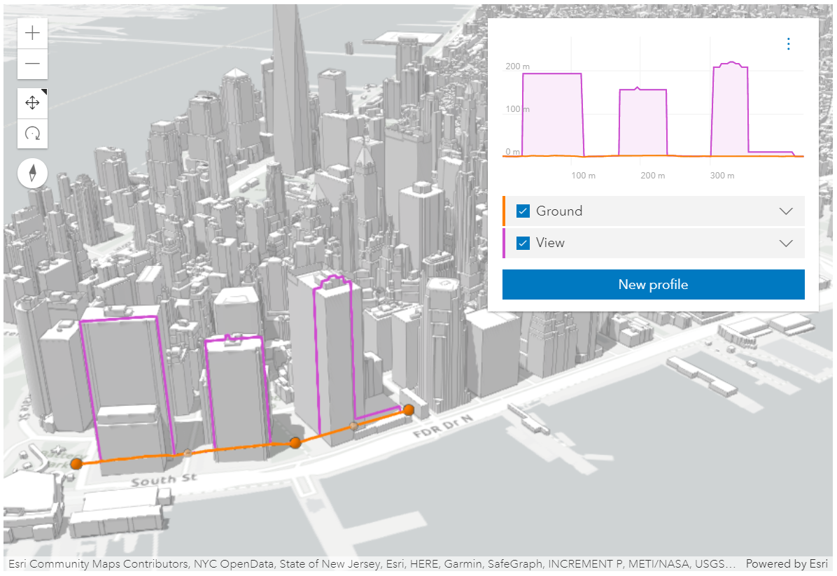 紫色建筑物剖面是类型视图的剖面线的结果。
- 另参阅:
const elevationProfile = new ElevationProfile({
  view: view,
  profiles: [{
    type: "view"
  }]
});
属性列表
| 名称 | 类型 | 描述 | 类 | |
|---|---|---|---|---|
| Color | 更多信息 图表和视图中线的颜色。 | 更多信息 | ElevationProfileLineView | |
| String | 更多信息 类名。 | 更多信息 | Accessor | |
| Array<(IntersectItem|Collection<IntersectItem>|Array<IntersectItem>|Ground)>|Collection<IntersectItem>|IntersectItem | 更多信息 从视图中查询高程时要排除的项目。 | 更多信息 | ElevationProfileLineView | |
| Point | 更多信息 点悬停在图表中视图的空间参考中。 | 更多信息 | ElevationProfileLine | |
| String | 更多信息 剖面线的唯一标识符。 | 更多信息 | ElevationProfileLine | |
| Array<(IntersectItem|Collection<IntersectItem>|Array<IntersectItem>|Ground)>|Collection<IntersectItem>|IntersectItem | 更多信息 从视图中查询高程时要命中的项目。 | 更多信息 | ElevationProfileLineView | |
| Number | 更多信息 此剖面的生成进展。 | 更多信息 | ElevationProfileLine | |
| ElevationProfileSample[] | 更多信息 构成高程剖面的样本列表。 | 更多信息 | ElevationProfileLine | |
| ElevationProfileStatistics | 更多信息 有关生成的高程剖面的统计信息(如果可用)。 | 更多信息 | ElevationProfileLine | |
| String | 更多信息 要显示在图表工具提示和图表图例中的线标题。 | 更多信息 | ElevationProfileLine | |
| String | 更多信息 线类型。 | 更多信息 | ElevationProfileLineView | |
| Boolean | 更多信息 是否应将表示 elevationSamples 的线可视化添加到 SceneView 中。 | 更多信息 | ElevationProfileLineView | |
| Boolean | 更多信息 是否应计算该线并将其显示在图表中。 | 更多信息 | ElevationProfileLine |
属性详细说明
-
图表和视图中线的颜色。
- 默认值:#cf4ccf
-
类名。类的名称声明格式为
geoscene.folder.className。
-
从视图中查询高程时要排除的项目。
-
点悬停在图表中视图的空间参考中。
-
剖面线的唯一标识符。
-
从视图中查询高程时要命中的项目。
-
此剖面的生成进展。0 表示未加载任何内容,1 表示加载完成。
-
-
构成高程剖面的样本列表。它可以传递到图形库,以便在 2D 中显示剖面。
-
-
有关生成的高程剖面的统计信息(如果可用)。对于坡度计算,在最小采样距离为10米(32.8英尺)处对剖面进行采样。在计算坡度之前,将更高分辨率的剖面缩减采样至 10 米(32.8 英尺)的采样距离。
-
要显示在图表工具提示和图表图例中的线标题。
-
type Stringreadonly
-
线类型。
对于 ElevationProfileLineView 类型总是 "view"。
-
viewVisualizationEnabled Boolean起始版本: GeoScene API for JavaScript 4.22
-
是否应将表示 elevationSamples 的线可视化添加到 SceneView 中。此属性不适用于 MapView。
- 默认值:true
-
是否应计算该线并将其显示在图表中。
- 默认值:true