从输入图形本身的几何对高程进行采样的剖面线,通常用于具有 z 值的输入行。如果输入图形是叠加的(高程模型为 ”on-the-ground“),则高程将从地面采样,以防场景具有地面图层。
在 2D 中,z 值不会从基于图层的要素中获取。因此,仅当输入要素是 MapView 中具有 z 值的客户端图形时,才会为 ElevationProfileLineInput 生成剖面。
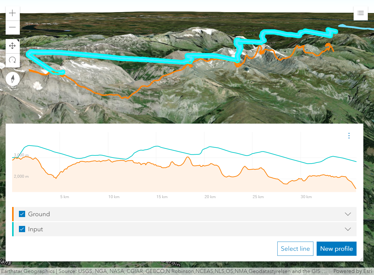 从具有 z 值的线要素生成的剖面。橙色剖面是使用输入类型的剖面线创建的。
- 另参阅:
const elevationProfile = new ElevationProfile({
  view: view,
  profiles: [{
    type: "input",
    color: "orange"
  }, {
    type: "ground",
    color: "lime"
  }]
});
属性列表
| 名称 | 类型 | 描述 | 类 | |
|---|---|---|---|---|
| Color | 更多信息 图表和视图中线的颜色。 | 更多信息 | ElevationProfileLineInput | |
| String | 更多信息 类名。 | 更多信息 | Accessor | |
| Point | 更多信息 点悬停在图表中视图的空间参考中。 | 更多信息 | ElevationProfileLine | |
| String | 更多信息 剖面线的唯一标识符。 | 更多信息 | ElevationProfileLine | |
| Number | 更多信息 此剖面的生成进展。 | 更多信息 | ElevationProfileLine | |
| ElevationProfileSample[] | 更多信息 构成高程剖面的样本列表。 | 更多信息 | ElevationProfileLine | |
| ElevationProfileStatistics | 更多信息 有关生成的高程剖面的统计信息(如果可用)。 | 更多信息 | ElevationProfileLine | |
| String | 更多信息 要显示在图表工具提示和图表图例中的线标题。 | 更多信息 | ElevationProfileLine | |
| String | 更多信息 线类型。 | 更多信息 | ElevationProfileLineInput | |
| Boolean | 更多信息 是否应将表示 elevationSamples 的线可视化添加到 SceneView 中。W | 更多信息 | ElevationProfileLineInput | |
| Boolean | 更多信息 是否应计算该线并将其显示在图表中。 | 更多信息 | ElevationProfileLine |
属性详细说明
-
图表和视图中线的颜色。
- 默认值:#00c8c8
-
类名。类的名称声明格式为
geoscene.folder.className。
-
点悬停在图表中视图的空间参考中。
-
剖面线的唯一标识符。
-
此剖面的生成进展。0 表示未加载任何内容,1 表示加载完成。
-
-
构成高程剖面的样本列表。它可以传递到图形库,以便在 2D 中显示剖面。
-
-
有关生成的高程剖面的统计信息(如果有)。对于坡度计算,在最小采样距离为10米(32.8英尺)处对剖面进行采样。在计算坡度之前,将更高分辨率的剖面缩减采样至 10 米(32.8 英尺)的采样距离。
-
要显示在图表工具提示和图表图例中的线标题。
-
type Stringreadonly
-
线类型。
对于 ElevationProfileLineInput 类型总是 "input"。
-
viewVisualizationEnabled Boolean起始版本: GeoScene API for JavaScript 4.22
-
是否应将表示 elevationSamples 的线可视化添加到 SceneView 中。此属性不适用于 MapView。
- 默认值:false
-
是否应计算该线并将其显示在图表中。
- 默认值:true