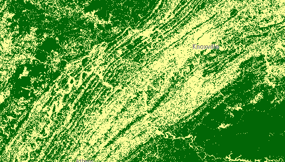
栅格函数指定要对影像服务执行的处理。它们允许镶嵌影像服务提供动态镶嵌影像,并且它们可用于通过应用影像增强和影像代数等处理操作来增强镶嵌影像产品。有关函数及其参数的列表,请参阅栅格函数 。下图显示了使用两个链接的客户端栅格函数渲染的土地覆盖物 ImageryLayer,这些函数用于对像素值进行重分类(重映射)并为每个像素分配一个新颜色(色彩映射表)。
通过将 functionArguments 属性中的栅格参数设置为另一个已定义的栅格函数,可以完成栅格函数的链接。请参阅下面的示例,了解如何将重映射栅格函数与色彩映射表链接在一起。
let remapRF = new RasterFunction();
remapRF.functionName = "Remap";
remapRF.functionArguments = {
  InputRanges: [-3,10,11,37], // remap pixels with values -3 to 10 to now have value of 1
  OutputValues: [1,2],        // remap pixel values from 11 to 37 to have a value of 2
  Raster: "$$"  // Apply remap to the image service
};
remapRF.outputPixelType = "u8";

let colorRF = new RasterFunction();
colorRF.functionName = "Colormap";
colorRF.functionArguments = {
  Colormap: [
    [1, 255, 0, 0],  // Symbolize pixels with value of 1 using red color
    [2, 0, 255, 0]   // Symbolize pixels with value of 2 using green color
  ],
  Raster : remapRF  // Apply Colormap to output raster from the remap rasterFunction
};

imageLayer.renderingRule = colorRF; // Set rendering rule to final raster function
构造函数
属性概述
| 名称 | 类型 | 描述 | 类 | |
|---|---|---|---|---|
| String | 更多信息 类的名称。 | 更多信息 | Accessor | |
| 对象 | 更多信息 栅格函数的参数。 | 更多信息 | RasterFunction | |
| String | 更多信息 栅格函数名称。 | 更多信息 | RasterFunction | |
| String | 更多信息 定义输出图像的像素类型。 | 更多信息 | RasterFunction | |
| 对象 | 更多信息 | 更多信息 | RasterFunction | |
| String | 更多信息 栅格函数的变量名称。 | 更多信息 | RasterFunction |
属性详情
-
起始版本:GeoScene API for JavaScript 4.7
-
类的名称。声明的类名的格式为
geoscene.folder.className。
-
functionArguments Object
-
栅格函数的参数。结构取决于指定的函数。有关函数及其参数的列表,请参阅栅格函数 。 还分析 RFT 格式的参数。
示例:rasterFunction.functionArguments = { "Azimuth":215.0, "Altitude":75.0, "ZFactor":0.3 };
-
functionName String
-
栅格函数名称。有关函数及其参数的列表,请参阅栅格函数 。RFT JSON 格式的栅格函数中的名称也会解析为函数名称。
示例:rasterFunction.functionName = "Stretched"; rasterFunction.name = "GrayScale";
-
outputPixelType String
-
定义输出图像的像素类型。
可能值:"c128"|"c64"|"f32"|"f64"|"s16"|"s32"|"s8"|"u1"|"u16"|"u2"|"u32"|"u4"|"u8"|"unknown"
- 默认值:unknown
示例:rasterFunction.outputPixelType = "u8";
-
rasterFunctionDefinition Object
-
-
variableName String
-
栅格函数的变量名称。
示例:rasterFunction.variableName = "DEM";
方法概述
| 名称 | 返回类型 | 描述 | 类 | |
|---|---|---|---|---|
| * | 更多信息 创建此类的新实例,并使用从 Geoscene 产品生成的 JSON 对象中的值对其进行初始化。 | 更多信息 | RasterFunction | |
| 对象 | 更多信息 将此类的实例转换为其 GeoScene portal JSON 表现形式。 | 更多信息 | RasterFunction |
方法详情
-
fromJSON(json){*}static
-
创建此类的新实例,并使用从 Geoscene 产品生成的 JSON 对象中的值对其进行初始化。传递到输入
json数的对象通常来自对 REST API 中的查询操作的响应或来自另一个 GeoScene 产品的 toJSON() 方法。请参阅指南中的 fromJSON() 主题,了解有关何时以及如何使用此功能的详细信息和示例。参数:json ObjectGeoScene 格式的实例的 JSON 表示形式。有关各种输入 JSON 对象的结构示例,请参阅 GeoScene REST API 文档。
返回:类型 说明 * 返回此类的新实例。
-
toJSON(){Object}
-
将此类的实例转换为其 GeoScene portal JSON 表现形式。有关更多信息,请参阅 fromJSON() 主题。
返回:类型 说明 对象 此类实例的 GeoScene portal JSON 表现形式。
